Tocht Stappen La Sentinelle - Valenciennes, autour du vignoble et de l'étang de Trith - Photo

Valenciennes, autour du vignoble et de l'étang de Trith

 papiou
papiou

Gebruiker

© OpenStreetMap contributors
Lengte
Lengte
8,4 km
Max. hoogte
Max. hoogte
34 m
Positief hoogteverschil
63 m
Km-Effort
Km-Effort  
9,2 km
Min. hoogte
Min. hoogte
15 m
Negatief hoogteverschil
62 m
Boucle
Boucle
Ja
Datum van aanmaak :
2016-11-13 00:00:00.0
Laatste wijziging :
2016-11-13 00:00:00.0

(0 Bericht)

Stappen
Stappen
1h51
Moeilijkheid : Heel gemakkelijk

Scan deze QR-code om de tocht te openen in de SityTrail-applicatie

Gratisgps-wandelapplicatie

Logo SityTrail SityTrail

IGN / Geografische instituten

SityTrail uit de App Store downloaden SityTrail uit Google Play downloaden

Logo SityTrail SityTrail World

De wereld gaat voor u open

SityTrail uit de App Store downloaden SityTrail uit Google Play downloaden SityTrail op Huawei AppGallery downloaden

Over ons

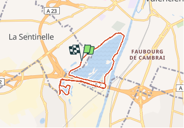
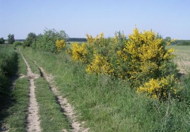
Tocht Stappen van 8,4 km beschikbaar op Hauts-de-France, Noorderdepartement, La Sentinelle. Deze tocht wordt voorgesteld door papiou.

Beschrijving

Rdv rue Robespierre en bas rue H. Durée sur zone Leroy Merlin. parking chemin de la vigne. Longer l'étang du vignoble par les vignes et rejoindre passage sous Pont autoroute,longer LME puis prendre à gauche chemin de Valenciennes a trith , sur gauche descendre les escaliers et faire le tour de l'étang de trith. revenir au point de départ par LME et passage sous le pont et rejoindre point de départ par l'autre coté du vignoble (club kayak et feu au lac)

Hoogteprofiel

Plaatsbepaling

Land:
France
Regio :
Hauts-de-France
Departement/Provincie :
Noorderdepartement
Gemeente :
La Sentinelle
Locatie:
Unknown
Vertrek:(Dec)
Vertrek:(UTM)
535103 ; 5577035 (31U) N.

Wandeltochten in de omgeving

Tocht Stappen Wallers - Mare goraux - Photo
Stappen
xcreator

Stappen

Medium
Wallers, Hauts-de-France, Noorderdepartement, France
6,8 km | 7,5 km-effort
1h 32min
Ja
Tocht Stappen Wallers - forêt de Raismes et mare à Gorriaux - Photo
Stappen
Templeuveenmarche

Stappen

Medium
(2)
Wallers, Hauts-de-France, Noorderdepartement, France
10,6 km | 11,7 km-effort
2h 35min
Ja
Tocht Stappen Hérin - Hérin, variante des 4 clochers - Photo
Stappen
papiou

Stappen

Gemakkelijk
Hérin, Hauts-de-France, Noorderdepartement, France
8,7 km | 9,2 km-effort
1h 58min
Ja
Tocht Mountainbike Maing - boucle autour de Maing - Photo
Mountainbike
Obeone2264

Mountainbike

Medium
Maing, Hauts-de-France, Noorderdepartement, France
16,5 km | 18,1 km-effort
2h 0min
Ja
Tocht Mountainbike Bellaing - Circuit de la Folle Emprise - Bellaing       - Photo
Mountainbike
tracegps

Mountainbike

Medium
Bellaing, Hauts-de-France, Noorderdepartement, France
11,3 km | 12,1 km-effort
1h 0min
Ja
Tocht Stappen Bellaing - Circuit de la Folle Emprise - Bellaing       - Photo
Stappen
tracegps

Stappen

Medium
(1)
Bellaing, Hauts-de-France, Noorderdepartement, France
11,3 km | 12,1 km-effort
2h 49min
Ja
Tocht Stappen Wallers - Circuit de la Mare à Goriaux - Arenberg - Photo
Stappen
tracegps

Stappen

Gemakkelijk
Wallers, Hauts-de-France, Noorderdepartement, France
6,9 km | 7,7 km-effort
1h 45min
Ja
Tocht Stappen Maing - Maing-circuit pas de boeuf, version 11km - Photo
Stappen
papiou

Stappen

Medium
Maing, Hauts-de-France, Noorderdepartement, France
11,2 km | 12,5 km-effort
2h 32min
Ja
Tocht Stappen Aubry-du-Hainaut - boucle 7 numerisee - Photo
Stappen
dehemjacques

Stappen

Heel gemakkelijk
Aubry-du-Hainaut, Hauts-de-France, Noorderdepartement, France
13,7 km | 14,8 km-effort
4h 21min
Neen


Sluiten
Mijn abonnementen